Gnarl Ridge
It had been a long time since I’d been up to Gnarl Ridge on Mount Hood’s east side. Almost six years, to be exact.
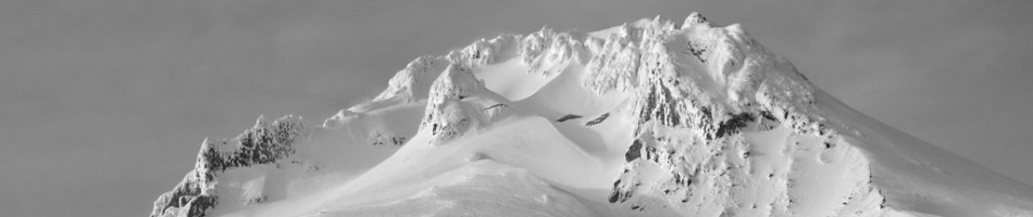
In fact, the last time I was up there, Amy and I were coming around the mountain from Cooper Spur on day four of our trip on the Timberline Trail. It was the first time I’d really been up that high on that side of the mountain and taken in such a unique perspective of it. From up there, Hood is massive, sprawling and broad, not at all like the textbook spire you see from the west or north.

Coming down Gnarl Ridge on the Timberline Trail in 2005.
And if there’s a ridge more aptly-named than Gnarl Ridge on the entire mountain, I have yet to find it. Its craggy spine is littered with crumbling gray, black, and red volcanic rocks. Its steep southern edge ends in a sheer, unstable plunge hundreds of feet down to the canyon of Newton Creek below, and the stunted trees — whitebark pines — that cling to the ridge just at timberline have been ravaged by the wind and the snow up there. The live ones look perpetually bent and braced for the next gust; the dead ones, bleached and stark, look like boney hands reaching up out of the ground.
Gnarly, indeed.
I ended back up on Gnarl Ridge this past weekend almost by accident, as the original plan had been to walk the mostly leisurely two-and-a-half miles to Elk Meadows and spend the night there. (I’d not been there since our Timberline Trail trip in 2005, either. The spot played a big role in how that hike ended up playing out, which I write about in my book.) But once Oliver, my friend Wyatt, and I got to the sunny meadows, we still had plenty of energy and daylight to press on, so we did.
We walked through the woods up from Elk Meadows and just enjoyed being outside in the finally summer-like weather. Just a week earlier, we’d hiked to the top of Silver Star Mountain through rain, mist, clouds, and a chill that was more mid-March than mid-July. Right about 5,500 feet, we hit some snow, but the trail revealed itself just often enough that we were able to keep on track. (A little GPS assistance kept us true as well.)
There were some decent campsites with partial views of Hood that would have worked fine if there’d been nothing else, but after Wyatt headed back down, Oliver and I trudged up to the top of Lamberson Butte — named for early Mazama Lewis Lamberson — surveyed the incredible views, and found some even better spots to pitch a tent.
So we spent a quiet night on Gnarl Ridge, watching the sun set on Hood, Jefferson, the Sisters and Bachelor, listening to the creek shush and the valley slowly erode with the rumble of a random boulder every so often.

The nighttime stars were immaculate. Off to the east, a Gorge wind farm pulsed faintly every ten seconds, puncturing the distant darkness with red pinpricks like Christmas tree lights. And in the morning, I somehow woke up just as the sun was rising, coloring the mountain and everything around it in a clear, golden glow.
It was good to be back on Gnarl Ridge.


Leave a comment