Kids on Cooper Spur
For starters, let me tell you this: It is completely possible to go backpacking on Mount Hood — or anywhere for that matter — with kids who are 2 and 6 years old.
Let me also tell you this: it is not easy.
And thirdly, I will say this: backpacking on Mount Hood with kids is not easy, but it is worth it. Entirely.

We started our recent excursion with a night up at the Cloud Cap Saddle Campground, where we explored the remnants of the Gnarl Ridge fire, which came close to roasting not only the campground but also the historic Cloud Cap Inn, the Snowshoe Club Cabin, and a few other irreplaceable gems back in 2008. Thankfully, crews back then were able to halt the fire just outside the historic structures while also allowing nature to run its natural course.


The next afternoon, we loaded up and started up the trail toward Cooper Spur, quite possibly the best day hike on all of Mount Hood. With Spencer on my back, heading above 30 pounds even before I added any gear and leaning this way and that, I do believe I can say I’ve carried the heaviest and most cumbersome pack I ever will. But the going was slow and steady, and eventually he fell asleep, which added a nice touch of stabilization.
Madeline’s gripes started about 15 minutes up the trail, but a little break and the promise of a stone fort just up ahead kept her spirits in check.

We made the camp site in decent time and set up for an evening of bouldering, sunset and mountain gazing, and simply soaking in the greatness that is life more than halfway up Mount Hood. It sounds relaxing and idyllic, and in a way it was, but let me also say that it was so nice to have an attentive aunt along for the ride.

The next morning, we set out for a little walk up the spur, knowing full well that not all of us would make it. The kids are troupers, to be sure, but all the way up Cooper Spur is not exactly a walk in the woods. It’s tough, it’s scrambling, and it’s a touch dangerous if you’re not completely careful. Even so, when I turned around with them at about 7,600 feet to head back down, I couldn’t help but think: Wow, how cool is that?

I wish I could say that every minute up on Hood was a smile and a grand view, but these pictures, they lie. Or at least they leave out the parts of the trip that weren’t incredible. The burden of the packs, the tantrums, the tumbles off the rocks, the spilled milk . . . But though we may remember those bits of this and any trip, there are other images, like those captured here, that we remember most, that make us smile in retrospect, entirely glad that we made the effort and the trip in the first place.

Mount Hood view — or not
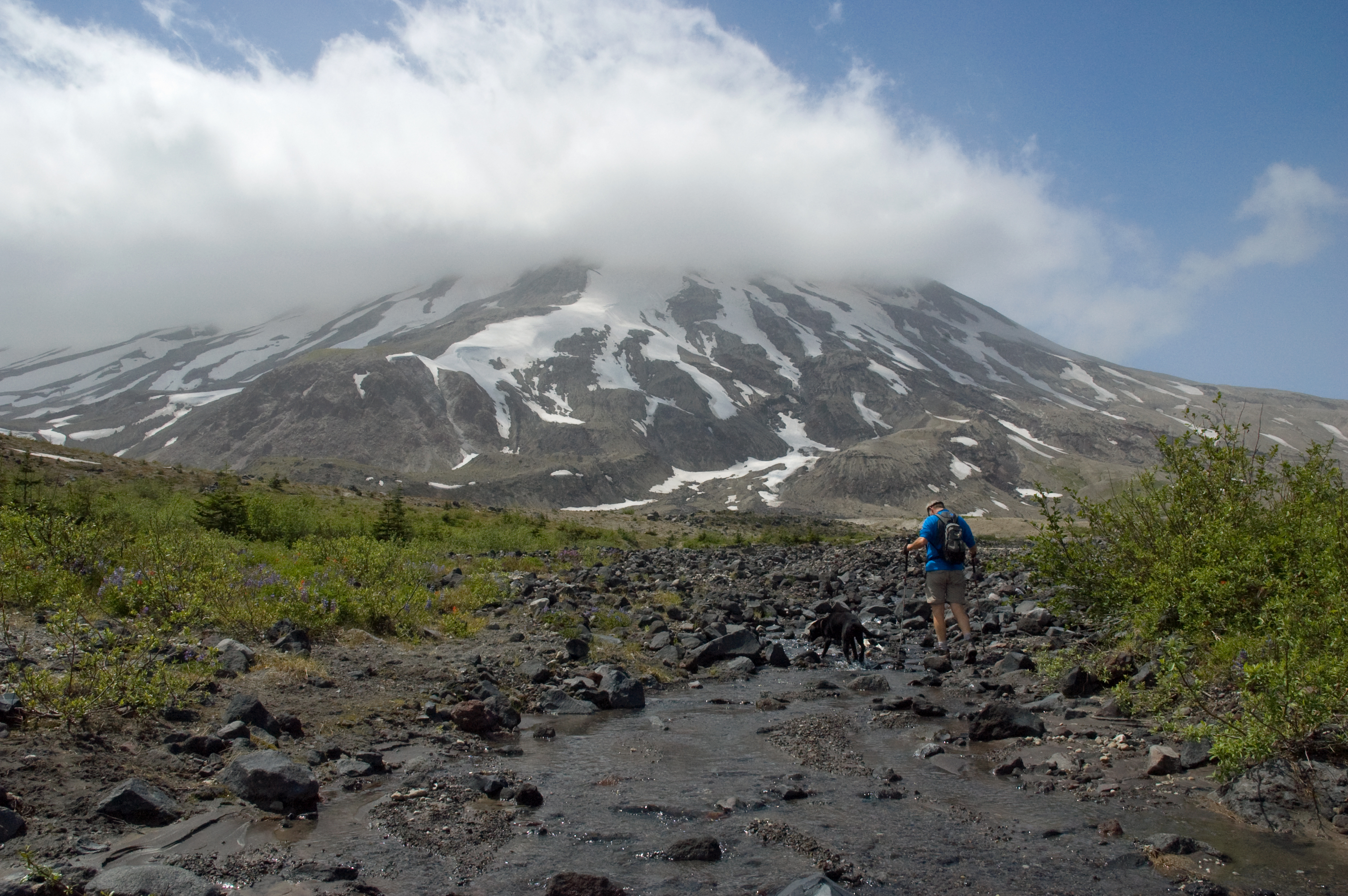
A few weeks ago, back before these hot and sunny days, back in mid July, when morning mist and clouds hung around far too long and blocked true summer’s appearance, my friend, Wyatt, and I headed east in search of some mountain sunshine. And we found it. Not, however, on Mount Hood.

Instead, we drove out of a Portland drizzle, Hood socked in behind a curtain of gray, and made our way over and up to the east side of Mount St. Helens. Up there, at Ape Canyon and all the way up to the Plains of Abraham — 13 miles roundtrip for us — we caught plenty of blue sky, sunshine, and giant if only partly cloudy views of the mountain.
The next weekend, it was still gray in town and there was April-like rain in the air. Still, we headed out, for if you only ventured out on clear, bluebird days, you’d surely be missing too much. This time, we headed to Hood and a standby favorite: Zigzag Mountain via Burnt Lake.
The clouds lifted once for a nice far-off view of the mountain about halfway up and then just again — just — before we topped out. (Look hard. It’s there.)

We didn’t get much else in terms of mountain views that day, but I’m not sure we really needed much more. Sometimes just being out and about, rambling in the hills, is more than enough.

Memaloose Hills Loop Trail
Today, resident Mount Adams expert and photographer Darryl Lloyd sent out an interesting map of a unique and unofficial wildflower trail out in the Columbia River Gorge in between Hood River and the Dalles. I’ve never done it, myself, but it sounds pretty nice — and it’s got at least one incredible view of Mount Hood along it’s 6.5-mile way. Thanks for sharing Darryl!


Mount Hood from Marsh Hill.
Tamanawas Falls Hike
The first time we did the beautiful Tamanawas Falls hike on the northeast side of Mount Hood, about seven years ago, our loads were a little lighter than they were this past weekend. Back then, it was just the two of us and a black lab puppy.

Tamanawas Falls, 2005
I remember the hike being pleasant enough, the falls pretty and natural. For some reason, though, what really stuck in my mind from that first time was a guy who had hiked the two miles back to the falls and was taking a break on the side of the trail. On his back was a pack full of his, I don’t know, maybe one-and-a-half-year-old daughter. At the time, I was pretty impressed and glad to see that he was still hitting the trail even though he had a little one in tow. It wasn’t an easy concept for me to grasp back then, pre-kids and all.
Not too long after that, however, I became that guy myself, heaving my daughter and then my son on my back to hit the trail at places like the Salmon River, Wind Mountain, and an all-time favorite, the beach near Bandon. Fast-forward a few more years, and the cycle’s progressed even a little further. The dog’s still bounding like he was in 2005, the boy’s still on my back at 2, but his big sister is now making her way down the trail and to the falls on her own.

The hike to Tamanawas Falls is a great one. Just under two miles one way and with less than 600 feet in elevation gain, the trail pretty much just ambles along the crystalline Cold Spring Creek through a quiet and, at times, dense fir forest. A couple stout log bridges make for easy stream crossings, and the cascading creek, towering trees, and easy, scenic terrain keep the mind on what’s important out in the wild. It’s an ideal Mount Hood hike for anyone looking to get out for a quick stretch of the legs and the senses. As I’ve come to learn over the years, it’s an even more ideal hike for those who are just learning how to stretch out their little legs and enjoy a walk in the woods.

Winter walking
When it comes to hiking, I’m ideally a fan of the alpine environment. I like to start out in the trees and hike up out of them, above timberline, to where the mountain views are widest. High up places like the Goat Rocks in Washington, Oregon’s Wallowa Mountains, and on Mount Hood spots like Cooper Spur, McNeil Point and Gnarl Ridge, define my kind of a walk in the woods.

Gnarl Ridge, Mount Hood
In the winter, however, a lot of the alpine country is much harder to access. And so, for hiking, we’re pushed downward to the river trails, maybe out to the Gorge or just east of the Cascades. This past weekend, we logged a few easy miles among the towering cedars and firs along the Salmon River trail in the Mount Hood National Forest, and while its views are much more subtle and understated than, say, the top of Old Snowy Mountain —

— it’s still among the best winter hiking to be found around Mount Hood. A few to consider:
- Salmon River Trail — An easy stroll along a beautiful and wild river — one of the only ones in the nation to be designated a Wild and Scenic River for its entire length — the Salmon River trail makes for a nice winter walk no matter the weather. It’s relatively flat, so it’s great for kids, and the moss-draped old growth Douglas firs and western red cedars that rise from the forest floor absolutely tower overhead, making you feel as if you’re walking through some kind of prehistoric era. The trail can be up to 7 miles long and there are lots of good places to stop for a break and turn around. To get there, take Highway 26 east from Portland to the town of Zigzag. Turn south on Salmon River Road and drive five miles to the trailhead on the left, just before a bridge over the river. More info.
- Hood River Mountain — This one’s a little ways away from the mountain, just outside Hood River, but its view of the peak and the entire Hood River Valley is simply jaw-dropping. Just three miles roundtrip and 600 feet up, Hood River mountain affords you a view that usually takes a lot more effort to attain. From Hood River, drive south on Highway 35 for just under a half-mile to East Side Road and turn left. According to Doug Lorain’s book, Afoot and Afield, “follow it 1.5 miles to the turnoff for Panorama Point County Park. Keep straight on East Side Road, and .4 mile after the park turnoff, turn left on Old Dalles Road. Drive east . . . for 2.1 miles to a saddle beneath a set of power lines. Park on the side of the road.” More information.
- Lower Creek Falls (Wash.) — Even farther from Mount Hood but still within reach for a day hike from Portland, Lower Creek Falls follows a serene Falls Creek, heads over a stunning suspension bridge, and tops out at the three-tiered Lower Creek Falls. Another great hike for kids and hounds. From Portland, head east on Highway 14 (in Washington) to milepost 47 and turn north toward Carson. Drive 14.5 miles on Wind River Road, pass the Carson National Fish Hatchery, and stay right on Wind River road for another 3/4 mile. Turn right on FS 3062 and drive 1.5 miles to the trail head. More information.
Too much to lose: Floras Lake and Blacklock Point
There is a place on the southern Oregon Coast where a cool Pacific breeze blows almost constantly off the steel-blue waters of the ocean, fanning out over fine brown-gray sand, bending and swaying long green blades of dune grass, brushing and bowling through stubby shore pines and tall inland Sitka spruce, reflecting off tawny sandstone cliffs that rise and tower over the wild shore. It is a place where purple and orange starfish and green anemones linger in salty tide pools, where seals spy and brown pelicans soar; a place where gray whales spout off in the distance and blue herons sail overhead.
Gazing from some lookouts, a near glimpse of the earth’s graceful curve; from others, waterfalls and crashing, foaming surf. There are occasional, subtle, tolerable signs of man: forest trails, colorful, far-off kite surfers, a small fishing boat, the clockwork pulse of the Cape Blanco Lighthouse under black skies spilling with stars.
Otherwise, this place, a sliver of shoreline south of Bandon near the tiny town of Langlois, is about as wild and as beautiful and as natural a place as is to be found along the entire Oregon Coast.

And yet, if commissioners from Curry County have their way, this place — it’s not hyperbole to summon the sacred here — would be cleaved and cleared, paved and pounded, planted with rough and greens, pocked with bunkers, soaked in poisons, manicured, homogenized and standardized, all in the name of a little white ball and a big green dollar bill.
Yes, the commissioners from Curry County, fearing for the solvency, maybe even the very existence, of the entire county, want to develop some of the most pristine and breathtaking land on the entire West Coast into . . . golf courses.

This so far informally proposed travesty came to my attention, coincidentally, on the very night that I returned home after an annual three-day backpack to this stretch of Oregon Coast with my family in late August. We’d just spent days in the sunshine, strolling the familiar sands — we’ve been coming back here for close to a decade — taking in the fresh ocean air, flying kites, slowing down, simplifying, refreshing. Late that night back at home, a headline in the Oregonian caught my eye. Its story dropped my jaw.
The short version: Curry County commissioners want to swap 68 acres of county land for 627 acres of Floras Lake State Natural Area, which has been part of the Oregon parks system since 1943. Through the swap, the county would create a new, 1260-acre county park. The land would be leased to a developer, who would then ransack it with two golf courses. One rendering shows a manicured green and two bunkers squarely on top of a dramatic sandstone plateau overlooking the Pacific. It is a landmark we know well.

The proposal also imagines an interpretive center — for what is a natural and scenic area without a center to interpret it? — and “improved” trails. Based on the county’s concept plan, that appears to mean paved.

All of this, the county supposes, would “create accessibility to public lands” and showcase “ecologically sound land management” and “preservation of native species.” It would also, in bold red letters, lead to “job creation” and “direct revenue for the general fund.”
To me, the entire idea is absolutely galling. Nonsense.
Thankfully, I am not alone. Public opposition seems to far outweigh support. Conservation groups such as the Kalmiopsis Audubon Society, the Oregon Shores Conservation Coalition, and the Portland-based Crag Law Center, all have lined up in opposition. And not only do people question the financial projections and oppose the destruction of this one-of-a-kind treasure, but there is a fishy odor in the air — and it’s not coming from the Pacific.
For months, the commission kept its proposal — and its work with potential developers — behind closed doors. In late June, the Oregon State Parks Department discovered 16 pits within the Floras Lake State Natural Area that had been illegally excavated with heavy equipment. The pits were discovered over an 8-mile section of trail between the southern edge of Floras Lake and Blacklock Point, which just so happens to be the area under consideration for development. No one seems to know who did it; as of today, Oregon State Police are still investigating.

This misguided proposal seems like a long shot for another reason, as well. According to the Oregon Parks and Recreation Department, projects that transfer state park property out of the park system are rare and must meet a high standard — providing “overwhelming benefits to the state park system.” This proposal does not meet that standard at all.
Still, the very fact that this idea is out there and that it’s being given official attention is, at the very least, troubling. It’s also an idea that you hear over and over again. Repackaged, maybe, but the gist is always the same: Develop — i.e. destroy — our most wild, pristine and beautiful places in the name of economic progress and increased access. It’s been tried on Mount Hood. It’s been suggested for Mount Adams. It’s come again now to the Oregon Coast.
Well, not this time. Not this wild, beautiful and scenic place. This one is too close to me. It’s too important. It is too much to lose.
Every time I come here, I am awed. We’ve been bringing our kids here practically every year since they were born. We will keep bringing them here, and one day — imagine — they may bring their kids here, too.
And it won’t be to play golf.

The Curry County Commission is holding an informational meeting at 5 p.m. today, Sept. 14, in Docia Sweet Hall of the Curry County Fairgrounds in Gold Beach. Members of the Oregon State Parks and Recreation Commission will be in attendance to hear details of the county park proposal.
Opposition comments can be submitted at any time to Chris Havel at the Oregon State Parks and Recreation Department (chris.havel@state.or.us) and to Curry County Commissioners George Rhodes (rhodesg@co.curry.or.us), Bill Waddle (waddleb@co.curry.or.us) and David Itzen (itzend@co.curry.or.us).
More information is available at the ODPR Floras Lake and Blacklock Point page and at www.savefloraslake.com